What Causes Sea Fog?
Sea fog poses a significant challenge to marine operations in the northern Gulf of Mexico. Locations such as Galveston and the Houston Ship Channel frequently experience visibility restrictions from sea fog during winter and spring.
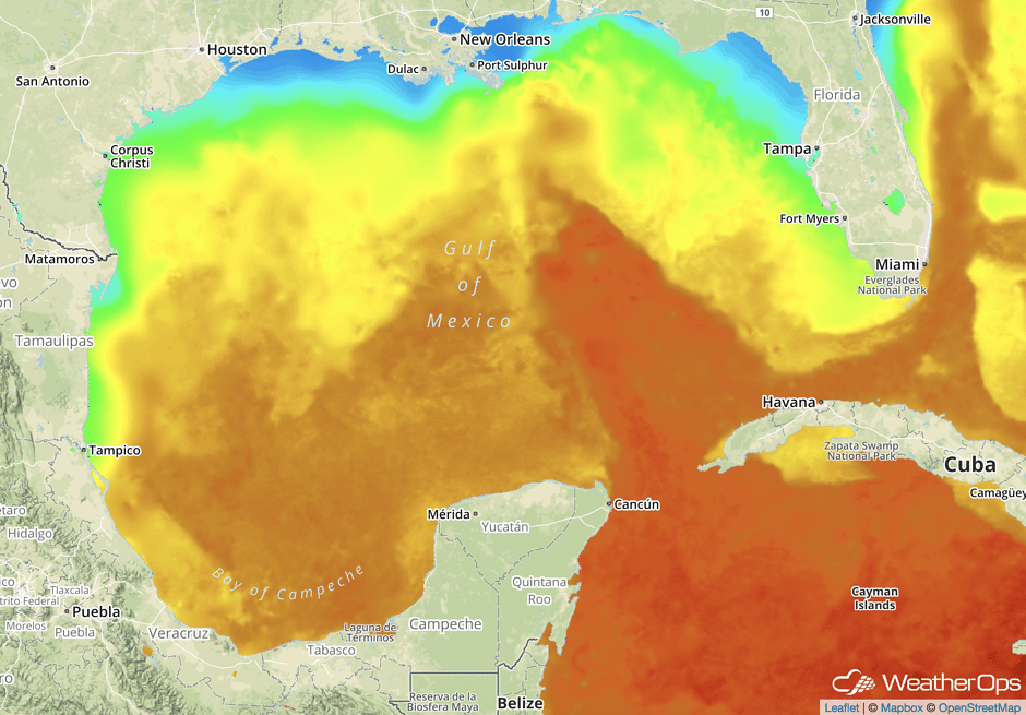
Sea fog forms when warm, moist air moves over colder water and cools to its dew point temperature, causing the air to saturate. This type of fog is favored over the northern Gulf during winter and spring as the higher frequency of cold fronts moving offshore cools the continental shelf waters, bays, and coastal waterways. It is less frequent in regions where the Sea Surface Temperatures (SSTs) remain above 20°C (68°F).
The extent of the cooler near shore waters and wind direction over that area affects the density and duration of sea fog events. In the wake of cold fronts, high pressure typically builds eastward across the southeastern U.S. This causes Gulf winds to gradually turn onshore. As the winds turn, warm, moist southern Gulf air with dew points in the 60’s to near 70°F moves northward across the cooled continental shelf waters. The amount of time this air spends traversing the cooler near shore waters has a significant impact on how dense the sea fog becomes. As such, an east to east-southeast wind that nearly parallels the northern Gulf coast provides the best trajectory for heavy sea fog (visibility <1/2nm). As winds continue to turn more southerly ahead of the next approaching front, the warm, moist air begins to cross the cooler waters more quickly and consequently has less time to cool to saturation. This motion can lead to some thinning or lifting of the sea fog but usually does not cause dissipation. Unlike inland radiation fog, sea fog persists until the air mass is changed by a frontal passage and may remain in place even when winds are 10 to 15 knots offshore.

An active winter weather pattern with frequent cold air surges can yield a 50+nm swath of SSTs in the upper 50’s to mid 60’s across the far northern Gulf of Mexico. These temperatures lay the groundwork for potentially long-duration dense fog events from late winter through spring when the high pressure to the east and onshore flow become more persistent.

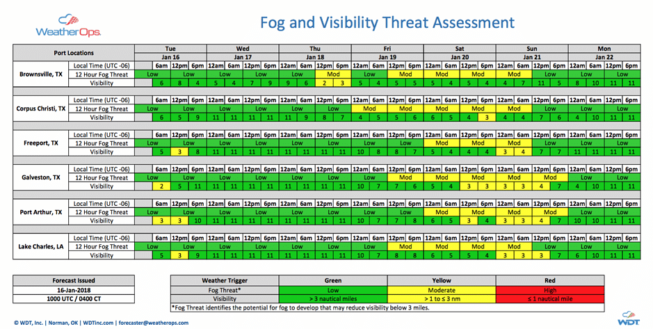
WeatherOps meteorologists have experience forecasting sea fog around the world and are trained to recognize the weather patterns that result in low visibility well in advance. Our Fog and Visibility Threat Assessments leverage our meteorologists’ insights, specialized forecast algorithms, and high-resolution model forecasts to project the threat and severity of sea fog events during the coming week. These reports provide a clear visual representation of the onset, duration, and severity of forecast fog events for customer-selected locations. Identifying the threat of dense sea fog days in advance provides the opportunity to modify shipping schedules, helicopter flights, and cruise turnarounds for the week ahead, potentially avoiding costly delays.


 Comprehensive weather insights help safeguard your operations and drive confident decisions to make everyday mining operations as safe and efficient as possible.
 Learn how to optimize operations with credible weather and environmental intelligence. From aviation safety to environmental compliance, our comprehensive suite of solutions delivers real-time insights, advanced forecasting, and precise monitoring capabilities.

