by WeatherOps, on Jun 17, 2014 9:46:48 AM
Severe thunderstorms are possible today for portions of the Northern Rockies into the Northern Plains, as well as the Western Great Lakes. General thunderstorms possible for portions of the Eastern Great Lakes and Pennsylvania.
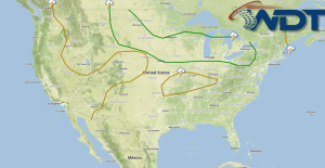
Current NWS Advisories/Watches/Warnings in iMapPro:
Severe weather is likely for most of the Northern US as a result of plentiful moisture, strong instability, and strong upper level winds. Storms will develop across portions of the Northern Rockies. Individual thunderstorms will have the potential to become supercellular with large hail, damaging winds, and tornadoes. Existing thunderstorms will become linear, posing more of a damaging wind potential. Instability will be in place across portions of Nebraska into the Western Great Lakes. While thunderstorms will not develop until afternoon, large hail and tornadoes will be possible. Storms will cluster tonight and move into the Great Lakes. Damaging winds will be the main concern, but large hail and tornadoes will also be possible. Thunderstorms ongoing across Michigan will weaken considerably, however, some redevelopment is possible as daytime heating increases. Large hail will be possible as they move through Southern Michigan, Northern Ohio, and Pennsylvania. Heavy rainfall will cause flooding for portions of the Northern Rockies and Plains.
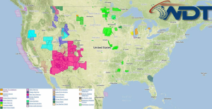
SPC Convective Outlook for Tuesday