by WeatherOps, on Jun 17, 2014 4:31:20 PM
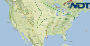
Severe thunderstorms will be possible on Wednesday for the Dakotas into the Great Lakes, the Great Lakes into the Northeast, and Nebraska into the Texas Panhandle.
Storms progressing eastward from today's activity should reintensify tomorrow from Illinois into Pennsylvania with hail and damaging winds possible. A strong upper level low continues to move eastward through the Northern Rockies. Severe thunderstorms will be possible from the Dakotas into the Great Lakes. Supercells capable of large hail, damaging winds and tornadoes will be possible. Flooding will also be possible in some areas.
A dryline extending from Nebraska to the Oklahoma and Texas Panhandles will allow for the development of thunderstorms capable of large hail and damaging winds.
SPC Convective Outlook for Wednesday