Thunderstorms will develop ahead of a cold front on Monday from Texas to the Lower Mississippi Valley; large hail and damaging winds will be possible with these storms.
Current NWS Advisories/Watches/Warnings:
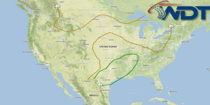
Thunderstorms over Oklahoma and Texas will continue to move eastward through the day. As they continue to move eastward, some reintensification is possible with large hail and isolated tornadoes. Further development is possible in Southeastern Texas ahead of existing outflow boundaries. Large hail and damaging winds will be possible. Areas from Central Texas to Tennessee could see 3 or more inches of rain, allowing for widespread flooding.