Showers will continue across portions of the Northeast today; some areas will have a flooding risk. Isolated showers and thunderstorms will be possible across the Intermountain West and Central Plains.
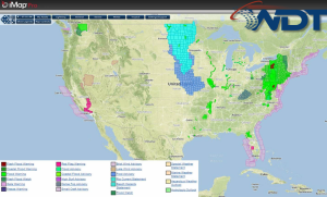
Current NWS Advisories/Watches/Warnings in iMapPro:
A cold front across the East Coast will push offshore today. General thunderstorms will be possible ahead of the front, in addition to widespread showers over the Northeast. 1-2 inches of rain, with locally higher amounts will be possible. Some isolated flooding will be possible. Elsewhere, isolated showers and thunderstorms will be possible from the Northern High Plains into the Tennessee Valley. While a few storms could become severe, severe activity will be sparse.