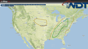
Showers and thunderstorms will be possible today from portions of the Ohio River Valley to the Gulf Coast; there will be the potential for severe thunderstorms and flooding.
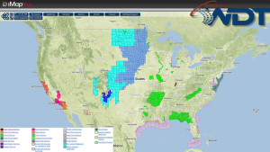
Current NWS Advisories/Watches/Warnings
A cold front will track through portions of the Northeast, Ohio River Valley, and Gulf of Mexico regions. Ahead of the cold front, severe thunderstorms will be possible from the Central Gulf Coast, northeastward across the Tennessee and Ohio Valleys, and toward the eastern Great Lakes. Strong winds, large hail, and a few tornadoes will be possible from the Tennessee Valley to the eastern Great Lakes. General showers and thunderstorms will be possible across the Western Gulf Coast, Southeast, Midwest, and Northeast.