


by WeatherOps, on May 9, 2014 9:49:53 AM
Scattered showers and thunderstorms will be possible today from portions of Texas to the Southern Great Lakes; some thunderstorms may be severe. General showers and thunderstorms will be possible from the Gulf Coast to the Northeast.
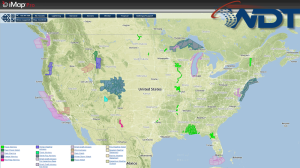
Current NWS Advisories/Watches/Warnings in iMapPro:
An upper level disturbance and cold front will continue to move eastward, bringing showers and thunderstorms from portions of the Gulf Coast to the Ohio River Valley. Large hail and damaging winds will be the main threats, but a few isolated tornadoes cannot be ruled out. The highest hail and damaging wind threat will be from South Central Texas into the Mid Mississippi River Valley and Northern Illinois into Central Indiana. The best tornado potential, though marginal, is from the mid Mississippi River Valley into the Southern Great Lakes.
Across the Southeast, moderate to heavy rain may lead some flash flooding. Up to an inch and a half of rain is possible.
SPC Convective Outlook for Friday
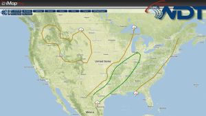
Across the Rockies, isolated showers and thunderstorms will be possible ahead of a disturbance moving into the Western US. Snow is possible in the highest elevations.
