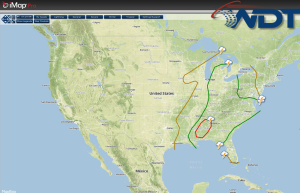
Severe thunderstorms are likely today across portions of the Southeast. Across the Midwest and Mid Atlantic, general showers and thunderstorms with isolated severe thunderstorms will be possible.
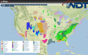
Current NWS Advisories/Watches/Warnings in iMapPro:
Rain and snow are expected through portions of Wyoming and Colorado, as well as Minnesota and Wisconsin. Accumulations will generally be under two inches, but isolated areas could pick up as much as 6 inches. Widespread showers and thunderstorms are likely for much of the Eastern US. General and severe thunderstorms are likely for portions of the Ohio River Valley and into the Carolinas. Isolated gusty winds and hail will be possible. More severe thunderstorms are possible for portions of the Gulf Coast. Straight line winds will be the main concern, but hail and tornadoes will also be possible. Additional thunderstorm development will be possible. Instability remains uncertain, but hail, damaging winds, and tornadoes will be possible.