by WeatherOps, on Apr 25, 2014 9:47:14 AM
Isolated severe thunderstorms are possible today for portions of the Mid Atlantic. Rain will continue for portions of the Pacific Northwest and Great Basin.
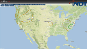
NWS Advisories/Watches/Warnings in iMapPro
A trough will be moving over the Ohio River Valley and toward the East Coast. As it does, the trailing cold front will move over Virginia and North Carolina, where thunderstorms developing will have the potential to become severe. Moisture and instability will be sufficient for the development of thunderstorms capable of large hail and damaging winds; a few tornadoes cannot be ruled out. By evening, thunderstorms should move off the coast and diminish.
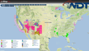
SPC Day 2 Outlook