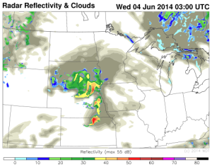
Thunderstorms are likely today for portions of the High Plains today as an upper level trough moves eastward across the Rockies. Daytime heating ahead of the cold front across the Plains and moisture advection will contribute to destabilization. With forcing from the upper level trough, thunderstorms will likely develop across the High Plains this afternoon. As thunderstorms develop, large hail and damaging winds will be the main concerns, but an isolated tornado cannot be ruled out. More thunderstorm activity is possible through the evening as a low level jet intensifies. Later in the evening, thunderstorms will congeal into a squall line, posing a mainly damaging wind risk.
WDT WRF Simulated Radar 10pm CDT Wednesday & 1am CDT Thursday