by WeatherOps, on Apr 21, 2014 9:47:32 AM
Showers and thunderstorms will be possible today from portions of the Southern Plains and Midwest. There is a slight risk for severe thunderstorms for portions of Central and Northeastern Texas. Rain and high elevation snow will also begin in portions of the Pacific Northwest.
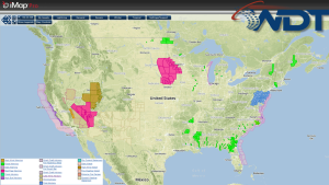
Current NWS Advisories/Watches/Warnings in iMapPro:
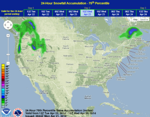
An area of low pressure over the Upper Mississippi River Valley will bring a cold front across the Central and Southern Plains today bringing a chance of showers and thunderstorms from portions of the Great Lakes to the Rio Grande, with severe thunderstorms possible from North Central Texas to the Arklatex region. Showers and thunderstorms are also possible from portions of the Mississippi River Valley to the western Great Lakes. A new area of low pressure will bring rain to the Pacific Northwest and snow to the Cascades.
WDT preferred forecast for 24 hour snow accumulation through 7AM Wednesday