Showers and thunderstorms will be possible for portions of the Southeast and Mid Atlantic on Tuesday. Rain and mountain snow will be possible for the Pacific Northwest and into the Northern Rockies.
A cold front will move east toward the Appalachians and East Coast on Tuesday, allowing for the development of thunderstorms, but no severe weather is expected. Any thunderstorms that develop will have the potential for hail. The trough moving into the Pacific Northwest will bring a chance for thunderstorms across the Northern and Central High Plains with light to moderate snow for portions of the Rockies.
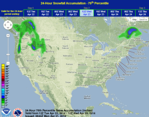
WDT preferred forecast for 24 hour snow and ice accumulation through 7AM Wednesday