Moderate to heavy snow will continue through the day for portions of the Northern Plains and Upper Midwest. Across the Central Rockies, a light to moderate snow mix can be expected. For portions of South Florida, showers and thunderstorms will be possible.
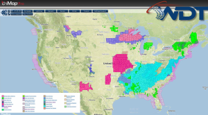
Current NWS Advisories/Watches/Warnings in iMapPro
The cold front that has moved across the US over the last few days is now offshore. The southern end of the front will stall across Southeast Florida and may generate a few showers and thunderstorms. Across the Northern Plains and Upper Midwest, an area of low pressure will continue to intensify and bring over a foot of snow to Northern Wisconsin and the Upper Peninsula of Michigan. Minneapolis and points northward will receive 4-6 inches of snow. A rain/snow mix will be possible of the Central Rockies, with snow in the highest elevations.
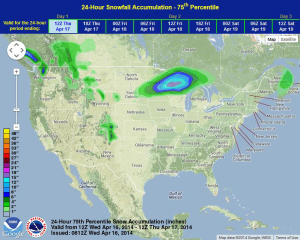
WDT preferred forecast for snow and ice accumulation through 7AM CDT Thursday