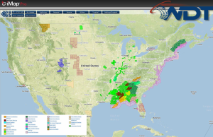
There will be a slight risk for severe thunderstorms for portions of Georgia, North Carolina, and South Carolina with the potential for hail, damaging winds, and tornadoes today. Across portions of northern New England, light snow will be possible.
Current NWS Advisories/Watches/Warnings in iMapPro
An area of low pressure will continue to progress out of the Southern Plains, moving northward along the east coast. Showers and thunderstorms are expected from the Southeast into the Northeast. Some isolated severe thunderstorms with damaging winds and hail will be possible, in addition to a few isolated tornadoes. Some areas of the Southeast will receive an additional two inches of rain, allowing for the potential for flooding.
Snow is also possible for the northern portions of New England. Up t0 4 inches of snow will be possible with locally higher amounts possible.