by WeatherOps, on Mar 31, 2014 9:31:23 AM
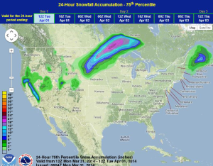
Moderate to heavy snow will continue throughout the day from South Dakota into Northern Minnesota. For the Sierra Nevada, moderate to heavy snow will be possible. Showers and thunderstorms will be possible for portions of the Midwest and Southwest.
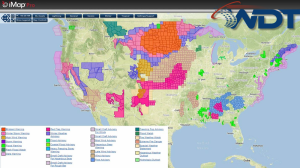
Current NWS Advisories/Watches/Warnings
Showers are continuing across the Mid Atlantic as an area of low pressure exits the Northeast. Across the Central Plains, a strong area of low pressure will bring heavy snow to portions of the Dakotas and Minnesota where 6-12 inches of snow will be possible. In addition, strong northerly winds with gusts to 45 mph will be possible for the Northern Plains and Upper Midwest. Hazardous travel conditions with low visibilities are expected. Showers and thunderstorms will be possible across portions of the Plains and Midwest, but no significant impacts are expected.
WDT preferred forecast for snow and ice accumulation through 7AM CDT Tuesday