by WeatherOps, on Mar 25, 2014 9:36:19 AM
Light to moderate snow, in addition to increasing winds will be possible today from the Central Appalachians to the Coastal New England areas. Showers and storms will be possible along the coast of the Pacific Northwest with moderate to heavy snow in the higher elevations of the Pacific Northwest and Northern Rockies. Showers and isolated thunderstorms will be possible for portions of West Texas into the Desert Southwest.
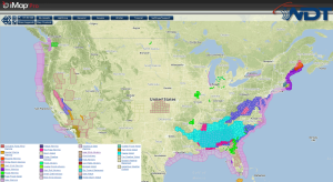
Current NWS Advisories/Watches/Warnings in iMapPro
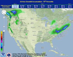
An area of low pressure and a cold front pushing across the Great Lakes and the St. Lawrence Valley is bringing some light snow to the Appalachians and Mid Atlantic. An area of low pressure developing off the coast of Florida will begin to move northeastward, parallel to the coast. This system will bring the potential for snow from Chesapeake Bay through eastern Massachusetts. 2-5 inches of snow will be possible in the Central Appalachians with locally higher amounts possible. Closer to the coast, 3-7 inches of snow will be possible, especially for portions of the Delmarva peninsula and southeast New England. Showers and possibly a few thunderstorms will be possible for portions of southwest Texas and the Desert Southwest. Heavy rain and snow will continue for portions of the Pacific Northwest ahead of an area of low pressure.
WDT preferred forecast for snow accumulation through 7AM CDT Wednesday