by WeatherOps, on Mar 24, 2014 9:29:57 AM
A rain/snow mix and light snow is likely today for portions of the Northern Plains and Midwest. For portions of the Gulf Coast and into Florida, showers and thunderstorms will be possible along a stalled front. Late in the day, valley rain and higher elevation snow will be possible for portions of the Pacific Northwest.
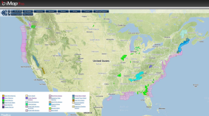
Current NWS Advisories/Watches/Warnings in iMapPro:
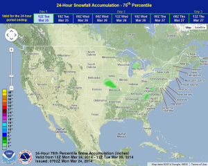
A fast moving clipper system will track from the Northern Plains into the Midwest and Great Lakes, generating light to moderate snow. In the Southeast, a stalled front across Florida will be the focus for thunderstorm development later today, however no severe weather is expected. A new area of low pressure will track into the Pacific Northwest and bring valley rains and higher elevation snow.
WDT preferred forecast for snow accumulation through 7AM CDT Tuesday