by WeatherOps, on Mar 21, 2014 9:42:06 AM
Light to moderate snow will fall across the Northern Plains and Upper Great Lakes, as well as the Central and Northern Rockies, today. Severe thunderstorms will also be possible for portions of the Southern Plains late today and into tomorrow.
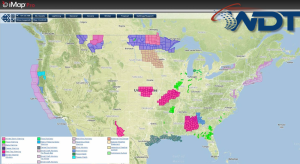
Current NWS Advisories/Watches/Warnings in iMapPro:
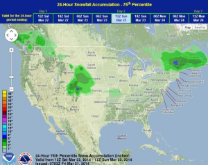
A clipper system moving across the Upper Mississippi Valley and Great Lakes will bring light to moderate snow to much of the area and a rain/snow mix for portions of the Lower Great Lakes. Accumulations will be less than 6 inches for most areas, but locally higher amounts are possible. Snow will also be possible for portions of the Northern and Central Rockies ahead of a front. Accumulations will generally be less than 4 inches, with some locally higher amounts on the peaks. This front will move into the Southern Plains and bring a chance for showers and thunderstorms from portions of Texas into portions of Arkansas. Large hail will be the main concern with these storms.
WDT preferred forecast for snow accumulation through 7AM CDT Saturday