by WeatherOps, on Mar 18, 2014 9:40:13 AM
Moderate to heavy snow will be possible today for portions of the Central Plains and the Upper Mississippi River Valley. For the Southern Great Lakes and Upper Midwest, showers and thunderstorms will be possible this afternoon. Light freezing rain is occurring currently over the Mid Atlantic. Light snow is possible for portions of the Intermountain West. Across Florida, showers and thunderstorms are possible early in the morning.
Current NWS Advisories/Watches/Warnings from iMapPro:
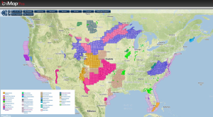
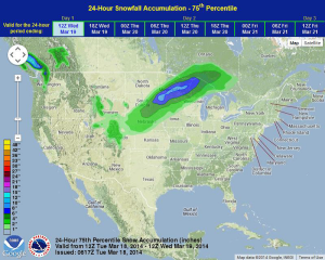
An area of low pressure over Southeastern Nebraska will lift Northeastward into the Mid and Upper Mississippi River Valley by this evening, bringing snow and light rain/freezing rain from the Central Plains into the Upper Mississippi River Valley. Some showers and thunderstorms will also be possible for the Southern Great Lakes. Severe thunderstorms are not expected, but lightning and winds to 40-45 miles per hour will be possible. The cold front associated with this area of low pressure will push through the Southern Plains, generating winds to 50 miles per hour across western portions of Oklahoma and Texas. The area of low pressure that affected the Southeast will continue to track northward, bringing light freezing rain and drizzle to portions of Virginia and North Carolina. While major impacts are not expected, travel may be affected tonight when surface temperatures fall below freezing.
WDT preferred forecast for 24 hour snow and ice accumulation through 7AM CDT Wednesday