Light to moderate snow will end across the Mid Atlantic by midday. Across Florida, isolated severe thunderstorms will be possible through the afternoon. For the Northern Rockies and the Northern Plains, light to moderate snow will be possible.
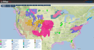
Current NWS Advisories/Watches/Warnings in iMapPro:
An area of low pressure moving across the Southern US and Mid Atlantic this morning has brought snow and ice from areas of New Jersey and southward into the Carolinas. An additional 1-2 inches of snow will be possible in addition to a tenth of an inch of ice for portions of Virginia and North Carolina. Across the Southern US, showers will continue from portions of the Carolinas and into Florida with severe thunderstorms possible from Northern Florida through Central Florida. The main threats from any thunderstorm will be heavy rain, hail to 3/4 inch, gusty winds to 50 mph, and an isolated tornado.
Across the Western US, an area of low pressure over the Pacific Northwest will move into the Northern Rockies. 4-8 inches of snow will be possible for the higher elevations with rain in the lower elevations.
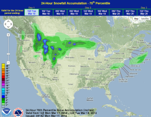
WDT preferred forecast for 24 hour snow and ice accumulation through 7AM Tuesday