by WeatherOps, on Mar 13, 2014 9:50:24 AM
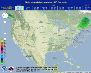
Light to moderate snow will be possible today for Northern Maine and the Mid Atlantic. In addition, the wildfire danger will remain high in these areas. Across the Central and Southern Plains, strong southerly winds will contribute to high wildfire danger. Across the Southwest, showers and thunderstorms will be possible.
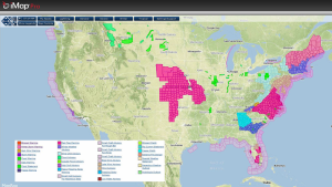
Current NWS Advisories/Watches/Warnings in iMapPro
Tranquil conditions will prevail as the frontal boundary affecting the Eastern US exits the region. Light to moderate snow will continue through the day for portions of Northern New England. Accumulations will remain less than six inches. Strong northerly winds this morning and afternoon will cause blowing snow and low visibilities, creating hazardous travel conditions. In addition, strong northwesterly winds at 15-25 mph through the Mid Atlantic region will keep the wildfire potential in place. As high pressure builds through the Southeast and Southern Plains, winds through the Plains will range from 10-20 miles per hour. With low humidity values, risk for wildfires will remain high. To the southwest, an area of low pressure will begin to develop through the Desert Southwest. Scattered showers and thunderstorms are expected in Arizona and New Mexico. Severe weather is not anticipated.
WDT preferred forecast for 24 hour snow and ice accumulation through 8AM EDT Friday: