Light to moderate snowfall will be possible today from the Central Rockies through the Southern Great Lakes. Showers and thunderstorms will be possible for portions of the Central Plains and Midwest and south to the Gulf Coast. Strong winds will also create the potential for wildfires.
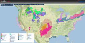
Current NWS Advisories/Watches/Warnings in iMapPro:
A cold front and an area of low pressure will move through the Central and Southern Plains today. A large swath of precipitation is expected from the Central Rockies through the Great Lakes. 2-6 inches of snow is expected with locally higher amounts possible. Gusty winds will allow for limited visibilities and snow drifts. Portions of the Midwest and Gulf Coast will see showers and thunderstorms. Moderate to heavy rain, lightning, and brief high wind gusts will be possible. Winds will range between 15-35 miles per hour with gusts up to 60 miles per hour possible. The wildfire risk will remain high for portions of West Texas, Oklahoma, and Kansas.
WDT preferred forecast for snow and ice accumulation through 7AM CDT Wednesday