by WeatherOps, on Mar 6, 2014 9:43:24 AM
Scattered showers and thunderstorms will be possible today across the Southeast with severe thunderstorms across Florida. Showers will also be possible along the Pacific Northwest coastline with moderate snow across the Intermountain West.
Current NWS Advisories/Watches/Warnings from iMapPro
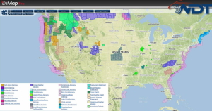
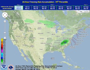
Showers and thunderstorms are ongoing across the Southeast ahead of a shortwave trough. A few isolated thunderstorms with the potential for small hail, damaging winds, and isolated tornadoes will be possible. Showers and thunderstorms will diminish after dark as an area of low pressure begins to lift northward along the Atlantic Coast overnight. A mix of light freezing rain, sleet and snow will be possible later tonight for portions of the Carolinas. Little to no accumulation is expected. Across the Northwest, scattered showers, in addition to moderate to heavy snow will continue across the higher elevations of Washington and into Wyoming and Utah. 4-8 inches of snow will be possible with isolated amounts up to a foot.
WDT preferred forecast for snow and ice accumulation through 6AM Sunday