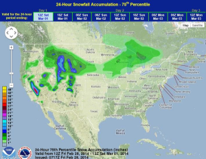
Heavy rain will continue for the valleys of California and the Rockies with moderate to heavy snow for the higher elevations today. Across the Great Lakes and Midwest, light to moderate snow will be possible late in the day.
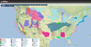
Current NWS Advisories/Watches/Warnings in iMap Pro:
A strong area of low pressure over the Pacific will move into California today allowing for periods of heavy rain and isolated severe thunderstorms. Any thunderstorms that develop will have the potential for heavy rain, lightning, winds to 50 miles per hour. The area of low pressure across the Rockies will shift into the Northern Plains, allowing for rain and thunderstorms. As the system moves into the Northern Plains, a cold front will begin to move southward, allowing for a chance of light snow across portions of the Midwest and Great Lakes. Wind chill advisories and warnings are in effect for portions of the Northern Plains and points eastward into the Northeast.
WDT preferred model for snow accumulation through 6AM CST Saturday
Portions of California are evacuating in advance for the potential for flooding. Rainfall rates may be as heavy as 1-2 inches per hour. Waterspouts and isolated tornadoes will also be possible.