by WeatherOps, on Feb 26, 2014 3:53:11 PM
Showers and isolated thunderstorms will be possible on Thursday for the lower elevations of California and into the Rockies, as well as moderate to heavy snow for the higher elevations. Lake effect snow will also be possible for Upstate New York.
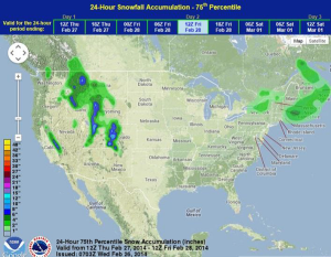
The area of low pressure over California will move into the Rockies on Thursday. Where moderate to heavy snow falls, up to 12 inches of snow will be possible.
Across the Northern Plains and Great Lakes, Wind Chill Watches and Warnings will be possible. Temperatures will be in the single digits and wind chills will approach -45. Temperatures will be 30-40 degrees below normal.
WDT preferred forecast for 24 hour snow accumulation through 6AM CST Friday