


by WeatherOps, on Feb 21, 2014 3:31:52 PM
On Saturday, light to moderate snow will continue for portions of the Intermountain West, Rockies, and Northern Plains. Across the Southern Great Lakes and Interior Northeast, light to moderate rain and snow will be possible tomorrow evening. Showers and thunderstorms will be possible for portions of the Gulf Coast and Florida. The cold front along the East Coast will continue to move offshore on Saturday, with the exception of Florida.
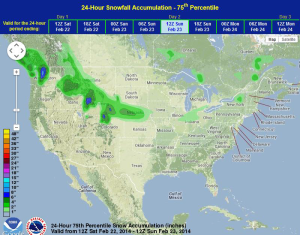
WDT preferred forecast for 24 hour forecast for snowfall through 6AM Sunday
A few shortwaves will track across the Intermountain West and Northern Plains, allowing for light to moderate snowfall throughout the day. The rain/snow mix across the Great Lakes and Northeast will eventually change to snow by Sunday morning.
Showers and thunderstorms will also be possible again on Sunday along the Gulf Coast and Southeast ahead of a cold front. Any storms that develop will have the potential for small hail and damaging winds.
