A severe thunderstorm outbreak is possible today for portions of the Ohio River, Mid-Mississippi River, and Tennessee River Valleys, as well as parts of the Gulf Coast. Damaging winds will be the main concern, however, tornadoes will also be possible. For portions of the Pacific Northwest, moderate to heavy snow will continue. Heavy snow and blizzard conditions will be possible for portions of the Upper Midwest and Great Lakes. Strong winds will also be possible across the Plains behind a cold front.
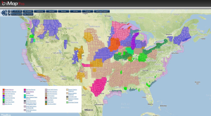
Current NWS Advisories/Watches/Warnings in iMapPro:
It will be a very active day for much of the Central Plains on Thursday. An area of low pressure is currently centered over Northwestern Oklahoma and Southwestern Kansas. A warm front extends eastward into the Mid-Mississippi and Tennessee Valleys. The warm front will continue to lift northward through the morning. The low over the Plains will continue strengthen as it continues to move northeastward. This will allow a cold front to move through the Southern Plains with winds up to 60 miles per hour possible behind the front. As the front continues to move eastward, a line of thunderstorms will develop into portions of the Mid-Mississippi River Valley and the Gulf Coast, and eventually the Ohio and Tennessee Valleys.
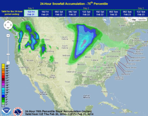
Northwest and north of the low, blizzard conditions will be possible for portions of Iowa, Minnesota, and Wisconsin. Heavy snowfall of 12-18 inches and wind gusts to 55-60 miles per hour will make travel difficult to impossible in these areas due to blowing and drifting snow.
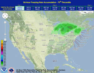
WDT preferred forecast for 24 hour snow and ice accumulation through 6AM Friday