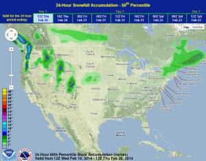
Moderate to heavy snow will continue for portions of the Pacific Northwest. For the New England region, a mid-level trough will bring mixed wintry precipitation throughout the day. In the Southeast, a few thunderstorms will be possible this afternoon and tonight. A few severe thunderstorms will also be possible for portions of the Central Plains and Mid Mississippi River Valley.
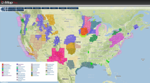
Current NWS Advisories/Watches/Warnings in iMapPro
A mid-level trough moving into the Northeast is bringing a mix of precipitation to much of Pennsylvania. Some sleet and freezing rain is possible, however, as temperatures rise above freezing, precipitation will transition to all rain. Across the Southeast, a few thunderstorms are possible ahead of a cold front. The main concerns with these storms will be heavy rain. An area of low pressure will develop in the lee of the Rockies later today. As this occurs, the warn front and moisture will move northward into the Central Plains and Mid Mississippi River Valley. This will allow for the development of thunderstorms over portions of Kansas, Missouri, and Oklahoma. Large hail and wind gusts to over 60 miles per hour will be possible. Rain and snow will also be possible for portions of the Pacific Northwest and Intermountain West.
WDT preferred forecast for snow and ice accumulation through 6pm CST Wednesday