Multiple disturbances will continue to produce moderate to heavy snow across the Cascades, Sierra, and the Northern and Central Rockies as well as heavy rain for portions of California and Oregon. Light snow and sleet is expected from portions of West Texas, across Southeast Oklahoma, and into Arkansas. A stalled front across the Florida Peninsula will bring moderate rain to portions of Northern Florida and Southern Georgia.
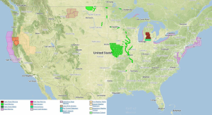
Current NWS Advisories/Watches/Warnings:
The precipitation occurring in Oregon and California will move into Utah, Wyoming, and eventually Colorado as low pressure systems continue to move east. Another area of low pressure will bring heavy rain to portions of Northern California today.
Across the Midwest and Great Lakes, cold conditions will continue, but there will be a slight warm up across the region with the exception of the far Northern Plains and northern portions of Minnesota and Wisconsin.
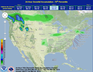
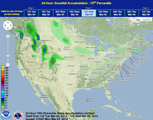
WDT preferred forecast for 24 hour snow and ice accumulation through 6AM CST Saturday
Light snow fell over North Texas early Thursday morning, leading to dangerous road conditions and accidents around the Dallas area. Utility officials were concerned that the cold temperatures could overwhelm the power grid and asked customers to lower their thermostats to 68 degrees and to avoid using large appliances during peak demand hours.