Disturbances moving into the Western US will bring heavy rain to portions of Oregon and California, as well as heavy snow to portions of the Cascades and the Sierra Nevada. Some light snow will continue over portions of Oklahoma and Northern Texas, as well as a wintry mix over Southeastern Texas. This activity will shift into Arkansas and Louisiana throughout the day. Very cold temperatures and winds will combine to create dangerously low wind chills for portions of the Northern and Central Plains.
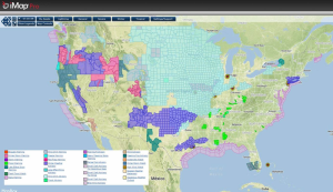
Current NWS Advisories/Watches/Warnings from iMapPro
Very cold temperatures are in place across the Plains, Upper Midwest, and Great Lakes behind a cold front. Sub-zero temperatures have been reported as far south as Southern Colorado and Kansas City. Wind Chill Advisories and Warnings are in effect across portions of the Plains and Upper Midwest.
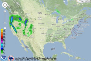
Heavy rain is ongoing this morning in portions of Northern California and will bring heavy snow to the Sierra Nevada ahead of the first of a series of disturbances. A second disturbance will bring moderate to heavy rainfall to portions of Oregon and heavy snow to portions of the Cascades. Some areas of the Sierras and the Cascades could pick up over a foot of snow through Friday morning.
Near Baltimore, MD, snow and freezing rain fell Tuesday night and Wednesday morning, making travel hazardous, closing schools, and causing massive power outages. As of yesterday afternoon, 13,000 customers were still without power. In New York and New Jersey, nearly half of all flights have been cancelled due to the snow.
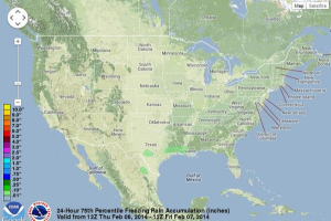
WDT preferred forecast for 24 hour snow and ice accumulation through 6AM CST Friday