


by WeatherOps, on Jan 28, 2014 9:46:08 AM
A wintry mix has developed across the Southeastern US overnight and will continue through Wednesday morning. Winter Storm Warnings are currently in effect from portions of Eastern Texas to Virginia.
Current NWS Advisories, Watches, and Warnings
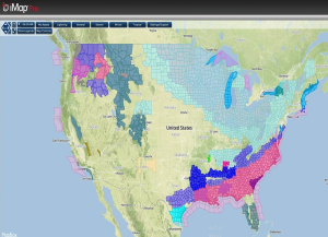
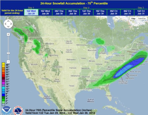
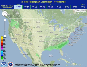
A strong cold front has approached the Northern Gulf, allowing for very cold lows this morning and wind chills as low as -50°F. Sleet, snow, and freezing rain will be possible from portions of the Gulf Coast to Virginia. In most places, ice accumulations will average around a tenth of an inch, however, some isolated areas of Georgia and South Carolina will see up to half an inch of ice. Snow accumulations will be heaviest for portions of the Eastern Carolinas with 4-8 inches (isolated areas up to 10 inches in the Eastern Carolinas and Southern Virginia).
Multi-model ensemble snow and ice accumulation
The Louisiana governor has declared an emergency statewide warning about the potential for the roads to become slippery. Icing was also reported on Interstate 49 near Alexandria, LA. In Louisiana alone, 45 of the 69 school districts would be closed as well as state offices in 46 of 64 parishes.
