


by WeatherOps, on Jan 23, 2014 12:16:48 PM
Rain across Southern and Eastern Texas will change over to freezing rain, sleet, and snow later tonight. This was the radar at 11:45am CST.

The transition from rain to sleet will begin late this afternoon as temperatures continue to fall.
WDT WRF Model Precipitation Type 4pm CST & 12pm CST
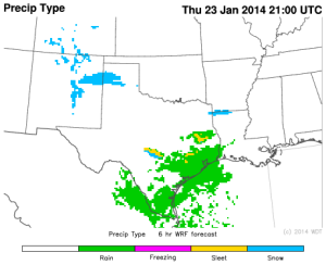
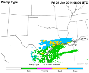
The mixture of sleet and snow will continue across portions of Southern, Eastern, and Central Texas through Friday morning. Ice accumulations will range from a tenth of an inch up to two tenths of an inch. Snow accumulations will be relatively low with up to an inch of snow for portions of Central Texas. Snow will come to an end across the state by mid to late Friday morning. Roads, especially overpasses, may be slick Friday morning around San Antonio, Houston, and Corpus Christi.
