


by WeatherOps, on Jan 22, 2014 9:51:18 AM
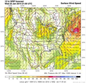
The winter storm that affected much of the Northeast yesterday is beginning to wind down, but another system will bring blizzard conditions to portions of the Dakotas and Minnesota today. Moisture is limited and snow accumulations will only be around half an inch, however, the bigger story will be the winds. Winds will increase to 35 miles per hour with higher gusts possible through the early evening. For portions of the Lower Peninsula of Michigan, 3-5 inches of snow will be possible through tonight.
WDT WRF model Surface Winds for 3pm CST Wednesday
WDT WRF model Snow Accumulation through 6AM CDT Thursday
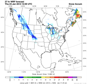
As the snow comes to an end across the Northeast, blizzard conditions will still be possible for Cape Cod and the islands. Winds to 30 miles per hour and gusts to 50 miles per hour will be possible, with an additional 2-4 inches of snow.
Several snow totals for the Northeast have been released. Here is a sample of the totals:
Greenwich, CT – 10.5 inches
Bridgeport, CT – 6.7 inches
Little Ferry, NJ – 13.4 inches
Secaucus, NJ - 12.5 inches
New York City, NY – 11.5 inches
Allentown, PA – 7 inches
Sharon, MA – 16.8 inches
Hanover, MA – 18 inches
Boston, MA – 4 inches
Washington, DC – 7 inches
