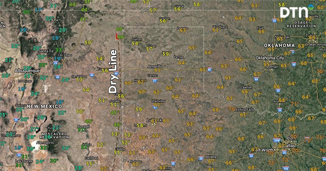
Dry Line Magic
Have you heard of the dry line before? If you live in the Texas Panhandle or Oklahoma, this is nothing new to you. Every spring, the dry line is talked about on severe weather days. So, what is it exactly and how does it relate to thunderstorm development?
The textbook definition of the dry line is that it is a boundary separating dry and moist air masses. There is a very sharp definition between the air in this area. When looking at a weather map, you can find it around the 55°F dewpoint line. In the image shows the dry line separating dewpoints in the 20s to low 50s from moister air in the Texas Panhandle.

Dry line magic occurs when storms form along this boundary. This doesn’t happen without some assistance from an upper air system and forcing which leads to instability. Warm air ahead of the dry line rises and, if the conditions are just right, forms a rotating, severe thunderstorm. These storms form either on the dry line or right ahead of it. It is not unusual for these storms to be isolated and become supercells producing tornadoes.
It is typical for the dry line to progress eastward during the afternoon hours and then retreat during the night. Therefore, storm development is not limited to daytime hours. In the following RadarScope loop, you can see the dry line retreating through Midland, Texas as the cold front advances. When these two boundaries meet, additional storms form quickly into a squall line.
https://www.facebook.com/RadarScope/videos/1449179651806817/
Picking out the dry line is sometimes a little more difficult on satellite imagery. Take a look at the following tweet showing data from the same day as the RadarScope image above. Once the storms form, you can see the air quickly dry out any further development in the Texas Panhandle. The storms continue to move into the higher dewpoints found further east.
#GOES16 captured this amazing infrared imagery of last night's powerful storms in the central US! See more loops @ https://t.co/z0YAKzuaYj pic.twitter.com/UIjdv2KxDr
— NOAA Satellites (@NOAASatellites) May 17, 2017
The dry line can often be found in the Great Plains in the spring. Just because it exists, it doesn’t automatically mean severe storms will form. However, next time you see radar or satellite imagery showing a line of single storms with tornado warnings in Texas or Oklahoma, look for the dry line. You’ll probably find it nearby!


 Comprehensive weather insights help safeguard your operations and drive confident decisions to make everyday mining operations as safe and efficient as possible.
 Learn how to optimize operations with credible weather and environmental intelligence. From aviation safety to environmental compliance, our comprehensive suite of solutions delivers real-time insights, advanced forecasting, and precise monitoring capabilities.

