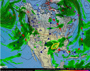
General thunderstorms and isolated strong thunderstorms will be possible for the Middle Mississippi Valley on Friday. Across the Northeast, rain, freezing rain, sleet, and heavy snow will be possible for portions of the Northeast. Scattered showers with locally heavy rain will be possible for the Pacific Northwest, Middle Mississippi and Ohio River Valleys.
Scattered thunderstorms are expected from the Arklatex into the Missouri Bootheel as moisture advects into the Lower Mississippi Valley. High pressure over the Northern Plains will reinforce an advancing cold front with the potential for a few marginally severe thunderstorms from the late morning through late afternoon. Gusty winds to 45 miles per hour and small hail will be the main concerns.
Across the Northeast, light snow, freezing ran, and sleet will continue in the higher elevations through the day. 4-6 inches of snow will be possible.
An area of low pressure will move into the Pacific Northwest and bring scattered showers to the coastal areas. Most areas will receive less than 2 inches of rain. Some runoff is possible.
For the Middle Mississippi and Ohio Valleys, thunderstorms will contribute to a heavy rain potential. 1-2 inches of rain, with locally higher amounts will be possible.