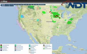
Scattered thunderstorms with isolated severe impacts will be likely today from the Upper Midwest to the Southern Plains; some thunderstorms may be severe. Isolated severe thunderstorms will be possible for the Mid Atlantic region as well.
Current NWS Advisories/Watches/Warnings in iMapPro:
An area of low pressure will move northward today into Saskatchewan with showers and thunderstorms expected from the Upper Midwest into the Mid Atlantic. Additional activity will be possible from Missouri into Northwest Texas. With any storms that develop, large hail and damaging winds will be the primary concerns. Conditions for severe thunderstorms will be most favorable across the Dakotas. Severe thunderstorms will also be possible across portions of Northern and Central Minnesota with large hail, damaging winds, and tornadoes possible.