


by WeatherOps, on Jun 18, 2014 9:45:14 AM
There will be three areas of concern for severe weather today. The first is from the Dakotas into the Great Lakes. The second from the Eastern Great Lakes into Pennsylvania. Lastly, from Nebraska through Texas. Flooding will also be possible for portions of the Great Lakes into Pennsylvania.
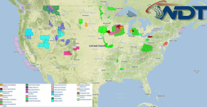
Current NWS Advisories/Watches/Warnings in iMapPro:
Moderate to strong instability due to plentiful moisture combined with a closed low and strong upper level winds will allow for the potential for severe weather today. The main area of concern will be across the Dakotas, Nebraska, and points eastward into the Great Lakes. An upper level low over the Western US will move into the High Plains today. A shortwave trough will also move southeastward through portions of Wisconsin and Michigan. This will allow for the development of thunderstorms with the potential for large hail, damaging winds, and tornadoes.
Ongoing storms across the Southern Great Lakes will have the potential to reintensify during the day. These storms could bow out with damaging winds being the primary concern, but large hail will also be possible.
A dryline across portions of the Plains through Texas will allow for the potential for thunderstorms due to daytime heating and strong instability. Large hail and damaging winds will be possinle.
