by WeatherOps, on Jun 16, 2014 9:44:22 AM
Severe thunderstorms are likely today for portions of the Central Plains and Upper Midwest. Further south, isolated severe thunderstorms will be possible for Northwestern Texas and Western Oklahoma. General showers and thunderstorms are possible across the Pacific Northwest.
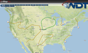
Current NWS Advisories/Watches/Warnings in iMapPro:
High pressure will build across the eastern US as a new area of low pressure moves into the Northwest. A moderately unstable atmosphere will pose a risk for strong to severe thunderstorms across portions of the Central Plains and Upper Midwest before noon. Additional thunderstorms will be possible across the Texas Panhandle and the Southeast.
More significant severe weather will be possible along and south of the South Dakota and Nebraska border into Iowa and southern Minnesota. Morning showers and thunderstorms have developed across Central Nebraska and will move northeastward. Large hail and damaging winds to 60 mph will be possible. A second area of thunderstorms will expand across Southern Minnesota and Iowa. These storms will transition into a larger complex with the potential for large hail, damaging winds, and tornadoes.
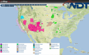
SPC Convective Outlook for Monday