Showers and thunderstorms will develop today across the Tennessee and Lower Mississippi Valleys. Large hail and damaging winds will be possible.
Current NWS Advisories/Watches/Warnings
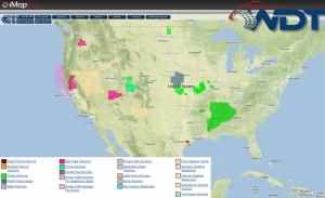
A closed low continues across portions of the Central US. Showers continue from Kansas into the Midwest, while general thunderstorms extend from western Tennessee into southeast Texas. Severe thunderstorms will remain possible across the Tennessee and Mississippi Valleys ahead of a pair of cold fronts. While large hail and damaging winds will be the main concerns, cloud cover will limit instability. A few thunderstorms will have the potential to become severe with large hail, damaging winds, and isolated tornadoes.