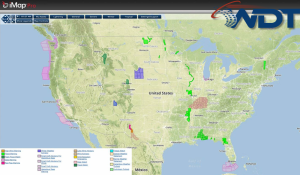
Scattered showers and thunderstorms will be possible for portions of the Plains and Midwest with a slight to moderate risk extending from Northern Texas to Southern Minnesota.
Current NWS Advisories/Watches/Warnings in iMapPro:
A strong shortwave trough will move into the Central Plains ahead of a frontal boundary and into the Upper Mississippi River Valley. Showers and thunderstorms will develop ahead of the ongoing activity. Severe thunderstorms are possible from North Texas into the Great Lakes region with the best potential across Western Iowa and Southern Michigan. Thunderstorms that develop in these regions will have the potential for hail larger than two inches, damaging winds, and tornadoes. Elsewhere, isolated severe thunderstorms will continue with the potential for damaging winds, hail to 2 inches, heavy rain, and frequent lightning.