by WeatherOps, on May 8, 2014 4:36:13 PM
Scattered showers and thunderstorms with a slight risk for strong to severe thunderstorms will be possible from the Arklatex region into portions of Indiana on Friday.
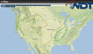
An upper level trough and cold front will continue to move eastward on Friday, bringing a broad area of showers and thunderstorms from portions of the Gulf Coast late in the day and into Saturday morning. Large hail and damaging winds will be the main concerns, but some isolated tornadoes cannot be ruled out. The best chances for severe weather will be from Northern Louisiana into Central Indiana. Rainfall amounts could reach up to 1.5" and could allow for isolated flooding across the Southern US.
SPC convective outlook for Friday