General showers and thunderstorms will be possible today for portions of the Southeast and into the Mid Atlantic. A few thunderstorms in the Mid Atlantic may be severe.
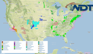
Current NWS Advisories/Watches/Warnings in iMapPro:
A broad trough will continue to linger along the East Coast for the next several days. For today, the cold front associated with the trough will provide the lift for the development of thunderstorms. The thunderstorm potential will be dependent upon the amount of daytime heating. If thunderstorms are able to develop, damaging winds and small hail would be the main threats, but an isolated tornado cannot be ruled out from the Delmarva Peninsula through the Carolinas.
A few severe thunderstorms will be possible for portions of Northern and Central Florida. Small hail and damaging winds will be possible with any storms that develop.