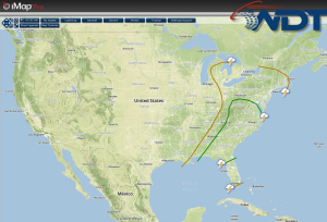
There is a slight risk for severe weather today for portions of the Southeast and Mid Atlantic. Across the Ohio River Valley, general showers and thunderstorms with a few isolated severe thunderstorms are possible.
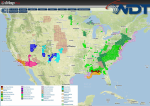
Current NWS Advisories/Watches/Warnings in iMapPro:
A cold front progressing eastward will confine any severe weather potential to the Eastern Seaboard. Isolated showers and thunderstorms (some severe) with the potential for large hail, damaging winds, and tornadoes will be possible from the Southeast into the Mid Atlantic and Appalachians. The highest severe weather potential will be from the Carolinas through the Delmarva peninsula.