


by WeatherOps, on Apr 24, 2014 11:54:05 AM
A large upper level system will move across the Central Plains this weekend, bringing the potential for severe weather to much of the Plains both Saturday and Sunday.
WDT WRF 500 mb Vorticity 1pm CDT Saturday
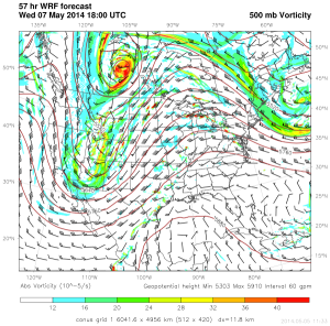
As this system continues to move east, and further destabilization occurs, thunderstorms with the potential for large hail (greater than 2"), damaging winds, and tornadoes will be possible. There will also be the potential for some strong tornadoes. One factor that may limit the thunderstorm development is the timing of the main upper level system; if it slows down, then the number of storms may be limited. Initially, thunderstorm development will be driven by daytime heating, but storms will likely continue into the evening hours as the main forcing arrives.
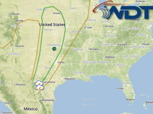
SPC Convective Outlook for Saturday
We will continue to monitor the latest information and update as necessary.
