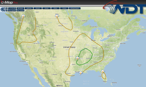
Showers and thunderstorms will be possible Thursday for portions of the Upper Midwest with severe thunderstorms possible for portions of the Mid Mississippi River Valley. Scattered showers are possible for the Pacific Northwest.
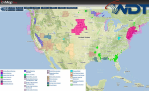
Current NWS Advisories/Watches/Warnings in iMapPro
An upper level disturbance that is progressing through the Southern Plains brought showers and thunderstorms from portions of Oklahoma northward into Iowa. This activity is not expected to pose any significant hazards. Further east, daytime heating will increase instability across portions of Arkansas, Missouri, Illinois, and Kentucky. By mid to late afternoon, severe thunderstorms will be possible; large hail and damaging winds will be the main concerns, but a tornado risk cannot be ruled out. The strongest of the storms will extend from Northeast Arkansas into Southeast Missouri.