Severe thunderstorms are likely today for portions of the Central and Southern Plains. Elsewhere, scattered showers are possible for the Upper Midwest, New England, and Pacific Northwest.
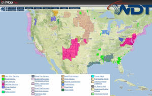
Current NWS Advisories/Watches/Warnings in iMapPro
An upper level trough will move into the Plains this afternoon with scattered showers and thunderstorms expected from North Dakota/Minnesota southward into Nebraska and Iowa. Further to the south, instability will increase through the morning ahead of a dryline. The dryline should extend from Western Kansas southward into the Texas Panhandle. Convergence ahead of the dryline and forcing from the upper level trough should be sufficient for thunderstorm development from Northwest Kansas into Northwest Texas. Large hail and damaging winds will be the main concerns, however, an isolated tornado cannot be ruled out. As storms move further east, a squall line may develop with the potential for straight line winds. Storms should weaken as they approach Interstate 35.