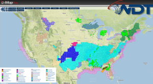
Showers and thunderstorms will continue for portions of the Northeast, with some flash flooding possible. Across the Eastern Great Lakes and Northern New England, moderate snow and light icing will be possible. Isolated severe thunderstorms and flooding will be possible for portions of the Mid Atlantic and the Southeast. A rain and snow mix is possible for portions of the Plains. Moderate sow is possible for portions of the Intermountain West.
Current NWS Advisories/Watches/Warnings in iMapPro:
A broad trough and attendant cold front will bring showers and thunderstorms to the entire East Coast on Tuesday. While heavier showers will develop across southern and western portions of New England, isolated severe thunderstorms will be possible from North Carolina to Florida with large hail and damaging winds possible. Flash flooding will be possible for portions of the Mid Atlantic/Southeast and Northeast/New England. Rainfall amounts will range from 1-2 inches with locally higher amounts near 3 inches possible. A rain/snow mix is possible for the inland portions of New England while the best chance for accumulating snow will be across the higher elevations of the Northern Appalachians. 3-6 inches of snow will be possible from portions of Upstate New York to Vermont. Light to moderate snow will be expected across the Intermountain West as an area of low pressure moves into the region.