by WeatherOps, on Mar 28, 2014 9:44:24 AM
Scattered showers and thunderstorms will be possible today for the Great Lakes and Northeast. Showers and thunderstorms will be possible for the Southeast, some of which may become severe. Showers and thunderstorms will be possible from Central Texas to the Lower Mississippi Valley. Some of these thunderstorms may be severe. In the Pacific Northwest and Northern Rockies, rain in the lower elevations and snow in the higher elevations will continue. A few thunderstorms will also be possible.
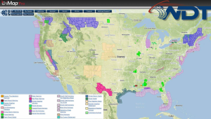
Current NWS Advisories/Watches/Warnings in iMapPro
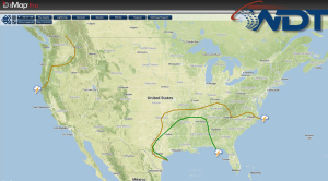
An area of low pressure is currently developing over the Central US and will deepen through the day as it moves into the Southern Plains. Showers and thunderstorms will be possible from areas of Central Texas to the Lower Mississippi Valley. A slight risk for thunderstorms exists across this area with the possibility for large hail, damaging winds, and isolated tornadoes.
Ongoing showers and thunderstorms stretching from Mississippi to Georgia will continue to progress eastward ahead of a cold front. While severe weather is not expected, isolated flooding is possible. Additional showers are ongoing across the Northern and Central Appalachians. This activity will move off the coast by dark. By early to mid afternoon, daytime heating will trigger thunderstorms from central Texas into eastern Texas. This activity will push into Arkansas and Louisiana tonight. The greatest chance for severe weather will be across Eastern Texas and eastward to the Mississippi River.
SPC Convective Outlook for Friday