by WeatherOps, on Mar 27, 2014 9:40:48 AM
Moderate to heavy snow and light icing is possible today for portions of the Great Lakes. Showers and thunderstorms will be possible for portions of the Southern Plains and Central Mississippi River Valley. Low elevation rain and higher elevation snow will be possible for portions of the Pacific Northwest and Rockies, in addition to thunderstorms.
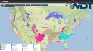
Current NWS Advisories/Watches/Warnings in iMapPro:
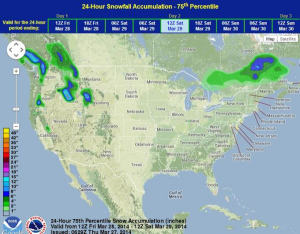
An area of low pressure moving across the Upper Midwest and Great Lakes will bring some snowfall to the Upper Mississippi Valley and Northern Great Lakes with some light icing possible. 4-8 inches of snow will be possible for portions of Minnesota and the Great Lakes with up to 10 inches possible in some areas. The associated front is moving across the Plains and Mississippi River Valley, which will bring a chance for thunderstorms from the Gulf Coast to the Lower Plains and points eastward through the Southeast and the Ohio River Valley. The main risk will be damaging winds, however, large hail and isolated tornadoes will be possible, especially across the Ozarks. A disturbance moving across the Northwest and Rockies may allow for some thunderstorm development, along with moderate to heavy snow across the Cascades and Northern and Central Rockies.
WDT preferred forecast for snow and ice accumulation through 7AM CDT Friday