by WeatherOps, on Mar 26, 2014 9:35:34 AM
Moderate to heavy snow, in addition to strong winds, will be likely for the coastal areas of New England and the Northeast; blizzard conditions will be possible. Showers and thunderstorms will be possible for portions of the Central Rockies into the Southern Plains. In the Pacific Northwest and the Northern Rockies, coastal rain and mountain snow will be possible.
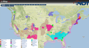
Current NWS Advisories/Watches/Warnings in iMapPro
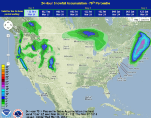
The area of low pressure off the East Coast is rapidly intensifying and is bringing storm force winds with hurricane force gusts from Cape Cod to Maine. Moderate to heavy snow on top of these strong winds will likely result in blizzard conditions into the afternoon. Elsewhere, an area of low pressure moving across the Plains and another disturbance pushing into the Pacific Northwest will bring precipitation and general thunderstorms to portions of the Plains, Rockies, and West Coast. Heavy snow is likely in the Sierras, Cascades, and Central and Northern Rockies.
WDT preferred forecast for snow and ice accumulation through 7am CDT Thursday